Data For Exploration Data packages Sanborn Maps Data Package
Sanborn Maps Data Package
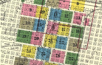
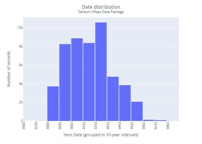
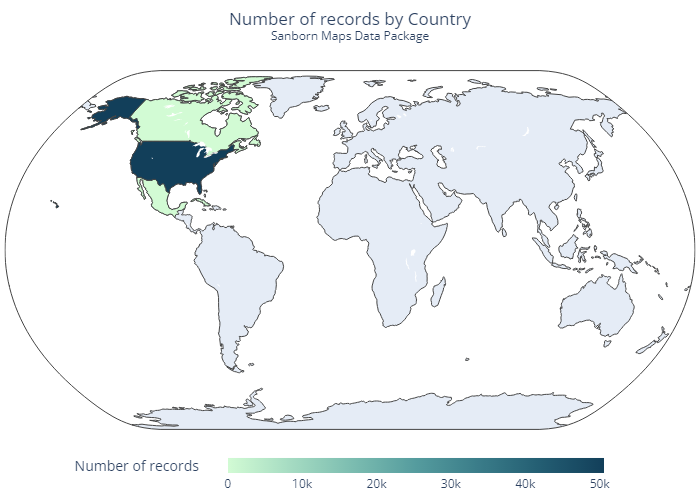
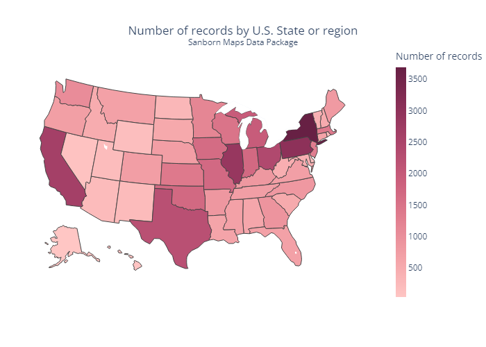
The dataset contains metadata records for 50,600 maps from the Sanborn Fire Insurance Maps collection and their corresponding 440,048 images . The Sanborn collection at Library of Congress includes over fifty thousand editions of fire insurance maps comprising almost seven hundred thousand individual sheets. The Library of Congress holdings represent the largest extant collection of maps produced by the Sanborn Map Company.
About this dataset
This dataset was created as part of an LC Labs experiment in collaboration
with AVP to understand the benefits, risks, quality benchmarks, workflows,
compilation methods, transformations, and documentation practices required
to assemble datasets for public use in the cloud. The dataset was completed
with support from the Geography and Map Division.
The target audiences of this dataset are users who want to explore spatial
or temporal aspects of a collection, plot data on a map or timeline, or
navigate or explore data by time or place.
The dataset contains
metadata records for 50,600 maps
from the Sanborn Fire Insurance Maps collection and their corresponding
440,048 images
. These records are included in CSV and JSON formats.
The dataset is organized by atlas, with each row (CSV) or JSON object
representing a single atlas from the collection. Each atlas may represent
one or more locations, and is geocoded to a single primary location, usually
at the city level.
| Metadata | Metadata formats | Data files |
|---|---|---|
| 50,600 records | .csv, .json | 440,048 .jpg images |
Data package documentation
Included in this data package is comprehensive documentation of source data or collection provenance, the contents of the data package, and how the data package was created. Here are some particular sections of interest as well as a link to the full documentation:
- About the source data or collection
- Computational readiness and possible uses
- How was it created?
- Dataset field descriptions
Dataset at a glance
How to access and use this data package
There are two main options for accessing and using this data package: (1) Directly downloading files from this page and (2) using Python for more advanced usage.
Direct downloads
The following list outlines the contents of this data package. Many of the individual files inside the data package are linked directly on this page which you can download and immediately use. Zipped files are available for bulk download of the entire or parts of the data package.
| Sample the data |
|
|---|---|
| Download the documentation |
|
| Download the metadata |
|
| Download the images |
|
Using AWS CLI
The contents of this data package are stored and accessed from Amazon Simple Storage Service (Amazon S3.) While many of the individual files inside the data packages are linked directly from this page (see Direct downloads above), you may want to browse or download large collections of files within the package.
This option requires you to download and install the free and open-source AWS Command Line Interface (AWS CLI) .
Once installed, open any terminal window (e.g. cmd, Terminal, Anaconda) and run the following to browse the files and directories within this data package :
aws s3 ls s3://loc-sanborn-maps/ --human-readable
Before downloading a directory of files, you can first review the list of files in that folder and all its subfolder and get a summary count of files and their total size :
aws s3 ls s3://loc-sanborn-maps/ --recursive --summarize --human-readable
You can download all the images in this data package using the sync command. Replace the directory at the end with the location you'd like the files saved into:
aws s3 sync s3://loc-sanborn-maps/maps-by-state/ D:/some/local/directory
Downloading all the images can take a very long time, so it is recommended to download the maps from the specific state or region you are interested in. To list the available states/regions , use this command:
aws s3 ls s3://loc-sanborn-maps/maps-by-state/ --human-readable
Then you can download all the data and images from a specific state or region like this:
                        aws s3 sync s3://loc-sanborn-maps/maps-by-state/Alabama/
                        D:/some/local/directory
If you want to preview the sync command without downloading anything , you can add the --dryrun option:
                        aws s3 sync s3://loc-sanborn-maps/maps-by-state/Alabama/
                        D:/some/local/directory --dryrun
Using Python
While direct downloads are more convenient for most activities, users with familiarity with writing Python can perform more advanced and complex tasks programmatically.
For your convenience we developed a number of Jupyter Notebooks to help get you started.
View the Python notebook for this data package
Dataset details
| Source collection |
The Sanborn collection at Library of Congress includes over fifty thousand editions of fire insurance maps comprising almost seven hundred thousand individual sheets. The Library of Congress holdings represent the largest extant collection of maps produced by the Sanborn Map Company. The majority of the maps were acquired through copyright deposit, but the collection was substantially enriched in 1967 when the Bureau of the Census transferred its sizeable collection to the Library. These additional maps had been used in the field, often for decades, and include updates in the form of printed, paste-on corrections from the Sanborn Map Company. Smaller numbers of Sanborn atlases have been acquired through purchase or donation. |
|---|---|
| Rights statement | The content of the Library of Congress online Sanborn Maps Collection is in the public domain and is free to use and reuse. For more information, see https://www.loc.gov/collections/sanborn-maps/about-this-collection/rights-and-access/ . |
| Date created | 2023-05-05 |
| Date updated | 2024-04-09 |
| Creators & contributors |
|
| Cite this dataset |
|
| Curatorial questions | For curatorial questions about the content of the collection or technical questions about the dataset formats and composition, please contact the Geography and Map Division via the Library's Ask a Librarian service at https://ask.loc.gov/map-geography . |
| Access questions | For questions and technical issues about download and access, please submit a ticket on Github or email the LC Labs Team at [email protected] . |